


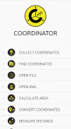

Coordinator-Collect Coordinate


Description de Coordinator-Collect Coordinate
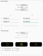
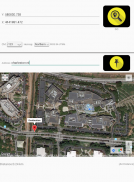
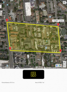
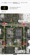
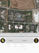
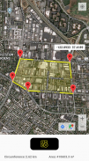
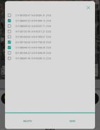
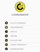
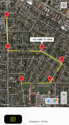
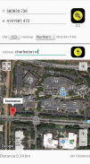
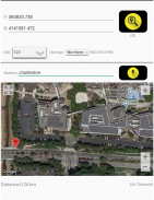
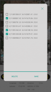
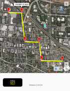
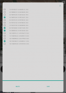
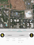
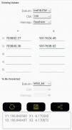
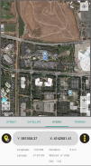
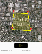
Using Coordinator app, you can collect coordinate data from land on whatever coordinate system you want, choosing from defined systems. You can collect GPS coordinates. You can view a coordinate data on the map and also you can search by address and see that on the map.(You can get directions to that point by clicking the red marker shown on the map). At the same time, you can learn the altitude value of the point and the distance between the point and your current location by long pressing on the map. Also you can see the distance and the elevation difference between two points created on the map. You can convert an existing coordinate into another coordinate system. You can do this by typing coordinates manually or opening an XLS file which contains coordinates. You can display circumference and area measurements of some coordinates by opening the file which created before using this app. Also you can measure circumference and area for some coordinates which determined manually on the map. Using this app, you can display a KML file on the map. Coordinator app contains several useful tools for people interested in coordinates, maps and geographic informations systems (GIS).
The coordinate systems of the countries, which the app is most downloaded, are added to the app.
Current list of the countries and their coordinate systems defined in this app:
World - GPS(WGS 84)
World - WGS 84 - 6 ̊ UTM
United States - "NAD 1983 HARN State Plane Coordinate Systems(meters & feet)" and "Military Grid Reference System (MGRS)"
Algeria - "Nord Sahara 1959 / UTM 6 ̊ "
Azerbaijan - "Pulkovo 1942 / Gauss-Kruger 3 ̊ " and "Pulkovo 1942 / CS63"
Bulgaria - "Pulkovo 1942(58) GK 6 ̊ "
Germany - "DHDN/3 ̊ GK" and "ETRS89 UTM 6 ̊"
India - "Kalianpur 1975 / India" and "Kalianpur 1975 / UTM 6 ̊"
Indonesia - "Indonesia 1974 UTM 6 ̊" and "DGN 1995 Indonesia TM3 ̊"
Iran - "ED50(ED77) / UTM 6 ̊"
Iraq - "Nahrwan 1967 / UTM 6 ̊" and "ED50 / Iraq National Grid" and "Karbala 1979 / UTM 6 ̊"
Israel - "Palestine 1923/Palest. Grid" and "Palestine 1923/Israeli CS Grid" and "Israel 1993/Israeli TM Grid"
Lebanon - "Deir ez Zor / Levant Ster." and "Deir ez Zor / Syria Lambert"
Mauritania - "Mauritania 1999 / UTM 6 ̊"
Morocco - "Merchich / Nord Maroc" and "Merchich / Sud Maroc"
Netherlands - "Amersfoort / RD New" and "Amersfoort / RD Old"
Palestine - "Palestine 1923/Palest. Grid" and "Palestine 1923/Israeli CS Grid" and "Israel 1993/Israeli TM Grid"
Philippines - "Luzon 1911 / Philippines" and "PRS92 / Philippines"
Romania - "Dealul Piscului 1930 / Stereo 33" and "Pulkovo 1942(58) / Stereo 70"
Russia - "Pulkovo 1942 / Gauss-Kruger 3 ̊"
Saudi Arabia - "Ain el Abd / UTM 6 ̊" and "Ain el Abd / Aramco Lambert"
Syria - "Deir ez Zor / Levant Ster." and "Deir ez Zor / Syria Lambert"
Turkey - "ITRF 96 - 3 ̊" and "ED 50 - 3 ̊" and "ITRF 96 - 6 ̊" and "ED 50 - 6 ̊"
United Arab Emirates - "Nahrwan 1967 / UTM"
À l'aide de l'application Coordinator, vous pouvez collecter des données de coordonnées de la terre sur le système de coordonnées de votre choix, en choisissant parmi les systèmes définis. Vous pouvez collecter des coordonnées GPS. Vous pouvez afficher les données de coordonnées sur la carte et vous pouvez également rechercher par adresse et voir cela sur la carte (vous pouvez obtenir des directions vers ce point en cliquant sur le marqueur rouge affiché sur la carte). En même temps, vous pouvez apprendre la valeur d'altitude du point et la distance entre le point et votre position actuelle en appuyant longuement sur la carte. Vous pouvez également voir la distance et la différence d'altitude entre deux points créés sur la carte. Vous pouvez convertir une coordonnée existante en un autre système de coordonnées. Vous pouvez le faire en tapant les coordonnées manuellement ou en ouvrant un fichier XLS contenant des coordonnées. Vous pouvez afficher les mesures de circonférence et de surface de certaines coordonnées en ouvrant le fichier créé avant d'utiliser cette application. Vous pouvez également mesurer la circonférence et la surface de certaines coordonnées déterminées manuellement sur la carte. En utilisant cette application, vous pouvez afficher un fichier KML sur la carte. L'application Coordinator contient plusieurs outils utiles pour les personnes intéressées par les coordonnées, les cartes et les systèmes d'informations géographiques (SIG).
Les systèmes de coordonnées des pays dans lesquels l'application est la plus téléchargée sont ajoutés à l'application.
Liste actuelle des pays et de leurs systèmes de coordonnées définis dans cette application:
Monde - GPS (WGS 84)
Monde - WGS 84 - 6 ̊ UTM
États-Unis - «NAD 1983 HARN State Plane Coordinate Systems (metres & feet)» et «Military Grid Reference System (MGRS)»
Algérie - "Nord Sahara 1959 / UTM 6 ̊"
Azerbaïdjan - «Pulkovo 1942 / Gauss-Kruger 3 ̊» et «Pulkovo 1942 / CS63»
Bulgarie - «Pulkovo 1942 (58) GK 6 ̊»
Allemagne - «DHDN / 3 ̊ GK» et «ETRS89 UTM 6 ̊»
Inde - «Kalianpur 1975 / Inde» et «Kalianpur 1975 / UTM 6 ̊»
Indonésie - "Indonésie 1974 UTM 6 ̊" et "DGN 1995 Indonésie TM3 ̊"
Iran - «ED50 (ED77) / UTM 6 ̊»
Irak - «Nahrwan 1967 / UTM 6 ̊» et «ED50 / Iraq National Grid» et «Karbala 1979 / UTM 6 ̊»
Israël - "Palestine 1923 / Palest. Grid" et "Palestine 1923 / Israel CS Grid" et "Israel 1993 / Israel TM Grid"
Liban - «Deir ez Zor / Levant Ster». et "Deir ez Zor / Syria Lambert"
Mauritanie - "Mauritanie 1999 / UTM 6 ̊"
Maroc - «Merchich / Nord Maroc» et «Merchich / Sud Maroc»
Pays-Bas - "Amersfoort / RD New" et "Amersfoort / RD Old"
Palestine - "Palestine 1923 / Palest. Grid" et "Palestine 1923 / Israel CS Grid" et "Israel 1993 / Israel TM Grid"
Philippines - "Luzon 1911 / Philippines" et "PRS92 / Philippines"
Roumanie - «Dealul Piscului 1930 / Stereo 33» et «Pulkovo 1942 (58) / Stereo 70»
Russie - "Pulkovo 1942 / Gauss-Kruger 3 ̊"
Arabie saoudite - «Ain el Abd / UTM 6 ̊» et «Ain el Abd / Aramco Lambert»
Syrie - «Deir ez Zor / Levant Ster». et "Deir ez Zor / Syria Lambert"
Turquie - «ITRF 96 - 3 ̊» et «ED 50 - 3 ̊» et «ITRF 96 - 6 ̊» et «ED 50 - 6 ̊»
Emirats Arabes Unis - "Nahrwan 1967 / UTM"
Coordinator-Collect Coordinate - Version 7.0.2c
(10-02-2021)
Coordinator-Collect Coordinate - Information APK
Version APK: 7.0.2cPackage: com.suleymaner.coordinatorplusAncienne Version de Coordinator-Collect Coordinate
Autres versions


Applications de même catégorie

Vous pourriez également aimer...


